Geographic Setting
The geographic setting of the study area can be examined through several thematic maps.
Landscape Region
Belgium can be divided into landscape regions, which define areas with similar holistic landscape characteristics. The study area is particularly interesting because it is split between two distinct landscapes (Digitaal Vlaanderen, 2026b): the Zennevallei and the Land van Dworp. The Land van Dworp is part of the Brabantse Leemstreek, characterised by open field landscapes, large parcels, a prevalence of arable land with scattered woodland, and larger woodland areas (Universiteit Gent, Vakgroep Geografie, 2026).
Terrain and Hydrography
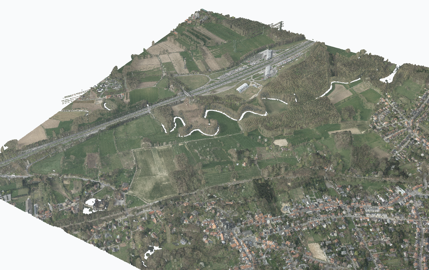
The terrain is very flat in the Zenne valley, with a valley floor at around 20 m above sea level. The Zenne is a meandering river that is part of the Dijle-Zenne basin (Integraal Waterbeleid, 2026). Beyond the alluvial plain of the Zenne, the terrain slopes upward, reaching a maximum altitude of 75 m within the study area. Gullies are formed by small tributary streams that feed the Zenne.
The terrain has also been shaped by human intervention. Relief has been raised for the construction of the E19/R0 highway to the west, and carved away by the construction of railway line 26. Older terrain alterations can also be seen in the hollow agricultural roads connecting the higher land and town with the alluvial plain. Some of these hollow roads are already present on the Ferraris maps from the late eighteenth century.
Soil Texture and Drainage
The soil texture consists of loam and clay in the lower alluvial plain of the Zenne. Outside the alluvial plain, sandy loam and sand are the most prevalent soil textures (Databank Ondergrond Vlaanderen, 2026a).
Soil drainage is highly variable, with some areas of poor drainage and other areas that are predominantly dry.
Geology
The tertiary geology of the study area belongs entirely to the Kortrijk Formation, with both the Saint-Maur and Moen members present. The Saint-Maur Member consists of silty grey clay, while the Moen Member transitions from grey clay to silt with distinct, interspersed clay layers (Databank Ondergrond Vlaanderen, 2026b). The Moen Member also contains Nummulites planulatus, large coin-shaped marine fossils belonging to the foraminifera group (Musée de l’apparent, 2026).
Forestry
A significant part of the study area and its surroundings is covered by forest. This forest is part of Brabantse Wouden National Park, but as can be seen in the orthophoto, these forests are not natural. Neither the 1770-1778 Ferraris map nor the 1846-1854 Vandermaelen maps show forests in the study area. The poplar plantations were established by the Catala paper mill starting in the nineteenth century and were used for commercial forestry until Catala went bankrupt in 2015 (Provincie Vlaams-Brabant, 2026a).
Infrastructure and Accessibility
Infrastructure is already a defining part of the study area’s geographic setting. The E19/R0 highway, railway line 26 and the surrounding national roads form strong linear elements that delimit, fragment and visually structure the landscape. They also influence accessibility: the centre of the study area remains relatively calm and is mainly reached through agricultural roads and paths, while the edges are shaped by high-capacity transport infrastructure. These features therefore act both as practical boundaries for the study area and as landscape-forming elements that return in the infrastructure map and horizontal relationship analysis. Beersel train station and the highway ramp make the study area very accessible by public transport or by car.
3D Visualisation
2D maps provide a useful overview of the study area, but a 3D view adds an extra dimension by revealing information about the height of structures and vegetation that can be difficult to interpret from 2D source material. A LiDAR point cloud published by Digitaal Vlaanderen (Digitaal Vlaanderen, 2026a) was downloaded and processed to create a 3D representation of the study area for this report.